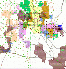
 This is a GIS map of the population of Maricopa County.
MCC NO LONGER OFFERS the Certificate of Completion in GIS.
You may contact Abeer Hamdan at Phoenix College regarding the possibility of a Certificate in GIS (abeer.hamdan@phoenixcollege.edu).
Geospatial Technologies is the term used to describe Geographic Information Systems (GIS), Geographic Positioning System (GPS), and Remote Sensing technologies.
These technologies are applied in a variety of settings by many different users including: Civil Engineering (CH2M Hill, HDR), Urban Planning (City of Phoenix, City of Chandler, City of Mesa), Natural Resource Management (Az Fish & Game, National Park Service, BLM), archeologists, biologists, and geologists.
These programs are built on a solid foundation in geospatial concepts, as opposed to training in the associated software only. Students are equipped with fundamental spatial analysis concepts and skills that can be applied in a variety of public and private work environments where spatial data analysis is required.


